|
Home
Catalogue
Information
Copyright
Other Stock Image websites

Latest additions -
Athens, ancient ruins, c1775
Pulo Penang, Malaysia, c1840
The Capitol, Washington, 1840
Middlesex county map, 1786
Philadelphia plan (SDUK), 1844
Lancashire county map, 1807
Ireland map, 1773
Austria-Hungary map, 1887
Notre Dame, Paris, 1840
Essex map, 1809
Eastern USA map, 1852
Calcutta view, 1850
Bohemia map, 1773
Dardanelles view, Turkey, 1828
Baltic Sea Tallis map, 1860
Plan of medieval Paris, 1884
Istanbul view, 1770
|
Download Royalty-free Stock Images of antique maps of Africa
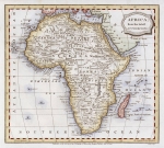
_tn.jpg) "Africa" engraved by G.Rollos, published in in Brooke's General Gazetteer, 1762. The original is a copper engraved map
and the hand colouring is recent. Click here for detail showing part of the map at full resolution (600 dpi). Click the small image
to the left for a larger low resolution version. (Ref sm0098). Digital
image 22.5mb at 600dpi. "Africa" engraved by G.Rollos, published in in Brooke's General Gazetteer, 1762. The original is a copper engraved map
and the hand colouring is recent. Click here for detail showing part of the map at full resolution (600 dpi). Click the small image
to the left for a larger low resolution version. (Ref sm0098). Digital
image 22.5mb at 600dpi.
Price 5 USD, Click here to buy
_tn.jpg) "Africa, from the best Authorities" anonymous engraver, published in a gazetteer in 1792. The original is a copper engraved map
with recent hand colouring. Click here for detail showing part of the map at full resolution (400 dpi). Click the small image
to the left for a larger low resolution version. (Ref sm0106). Digital
image 8.5mb at 400dpi. "Africa, from the best Authorities" anonymous engraver, published in a gazetteer in 1792. The original is a copper engraved map
with recent hand colouring. Click here for detail showing part of the map at full resolution (400 dpi). Click the small image
to the left for a larger low resolution version. (Ref sm0106). Digital
image 8.5mb at 400dpi.
Price 5 USD, Click here to buy
_tn.jpg) "
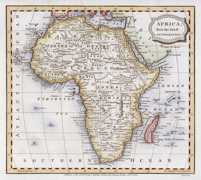
Africa " engraved by Barlow, published in Suffolk by Brightley &
Kinnersley in A General View of the World, 1806. The original is a copper engraved map
and the hand colouring is original. Click here for detail showing part of the map at full resolution (600 dpi). Click the small image
to the left for a larger low resolution version. (Ref sm0022). Digital
image 14.5mb at 600dpi. "
Africa " engraved by Barlow, published in Suffolk by Brightley &
Kinnersley in A General View of the World, 1806. The original is a copper engraved map
and the hand colouring is original. Click here for detail showing part of the map at full resolution (600 dpi). Click the small image
to the left for a larger low resolution version. (Ref sm0022). Digital
image 14.5mb at 600dpi.
Price 5 USD, Click here to buy
 "
Africa " engraved by Barlow, published in Suffolk by Brightley &
Kinnersley in A General View of the World, 1806. The original is a copper engraved map
and the hand colouring is recent. Click
here for detail showing part
of the map at full resolution (800 dpi). Click the small image
to the left for a larger low resolution version. (Ref sm0002). Digital
image 32mb at 800dpi. "
Africa " engraved by Barlow, published in Suffolk by Brightley &
Kinnersley in A General View of the World, 1806. The original is a copper engraved map
and the hand colouring is recent. Click
here for detail showing part
of the map at full resolution (800 dpi). Click the small image
to the left for a larger low resolution version. (Ref sm0002). Digital
image 32mb at 800dpi.
Price 5 USD, Click here to buy
_tn.jpg) "Africa" published by
Oliver & Boyd in Ewing's New General Atlas, 1847. The original is a lithographic map with
recent hand colouring. Click
here for detail showing part
of the map at full resolution (600 dpi). Click the small image
to the left for a larger low resolution version. (Ref sm0107). Digital
image size 17 mb at 600 dpi. "Africa" published by
Oliver & Boyd in Ewing's New General Atlas, 1847. The original is a lithographic map with
recent hand colouring. Click
here for detail showing part
of the map at full resolution (600 dpi). Click the small image
to the left for a larger low resolution version. (Ref sm0107). Digital
image size 17 mb at 600 dpi.
Price 5
USD, Click here to buy
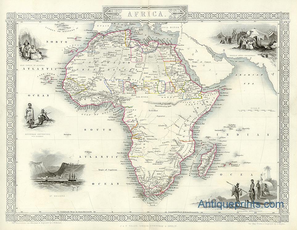
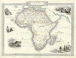 "
Africa " drawn and engraved by John Rapkin, published by
J.F.Tallis about 1850. The original is a steel engraved map with
original outline hand colouring. Click
here for detail showing part
of the map at full resolution (600 dpi). Click the small image
to the left for a larger low resolution version. NOTE - The original has a centre-fold
which is visible in the digital version. (Ref sm0009). Digital
image size 34 mb at 600 dpi. "
Africa " drawn and engraved by John Rapkin, published by
J.F.Tallis about 1850. The original is a steel engraved map with
original outline hand colouring. Click
here for detail showing part
of the map at full resolution (600 dpi). Click the small image
to the left for a larger low resolution version. NOTE - The original has a centre-fold
which is visible in the digital version. (Ref sm0009). Digital
image size 34 mb at 600 dpi.
Price 5
USD, Click here to buy
Also available as a photo or giclee print here on Mapseeker
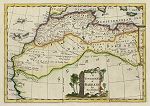 "An Accurate Map of Barbary, by G.Rollos Geogr." (North west Africa) copper engraved antique map, published in Fenning's A New System of Geography ..., 1773. The original is a copper engraved map
with recent hand colouring, measuring 28.5 x 19.5 cms plus margins. Click
here for detail showing part
of the map at full resolution (400 dpi). Click the small image to the left for a larger low resolution version. (Ref sm0235). Digital image
14.3mb at 400dpi. "An Accurate Map of Barbary, by G.Rollos Geogr." (North west Africa) copper engraved antique map, published in Fenning's A New System of Geography ..., 1773. The original is a copper engraved map
with recent hand colouring, measuring 28.5 x 19.5 cms plus margins. Click
here for detail showing part
of the map at full resolution (400 dpi). Click the small image to the left for a larger low resolution version. (Ref sm0235). Digital image
14.3mb at 400dpi.
Price 5 USD, Click here to buy
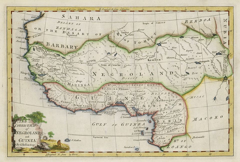
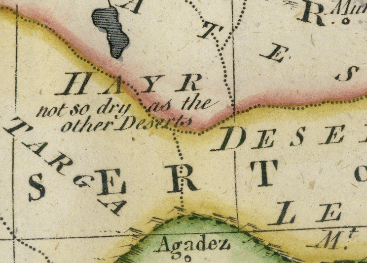
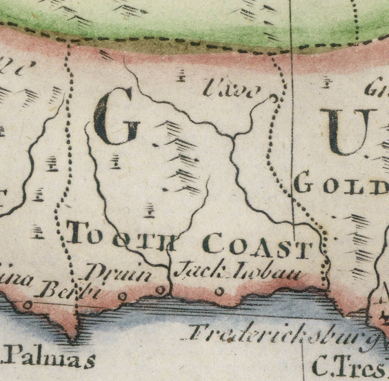
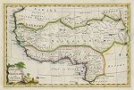 "A New & Correct Map of Negroland and Guinea, by G.Rollos Geogr." (West Africa) copper engraved antique map, published in Fenning's A New System of Geography ..., 1773. The original is a copper engraved map
with recent hand colouring, measuring 30.5 x 20 cms plus margins. Click
here for detail showing part
of the map at full resolution (400 dpi). Click the small image to the left for a larger low resolution version. (Ref sm0237). Digital image
15.1mb at 400dpi. "A New & Correct Map of Negroland and Guinea, by G.Rollos Geogr." (West Africa) copper engraved antique map, published in Fenning's A New System of Geography ..., 1773. The original is a copper engraved map
with recent hand colouring, measuring 30.5 x 20 cms plus margins. Click
here for detail showing part
of the map at full resolution (400 dpi). Click the small image to the left for a larger low resolution version. (Ref sm0237). Digital image
15.1mb at 400dpi.
Price 5 USD, Click here to buy
_tn.jpg) "
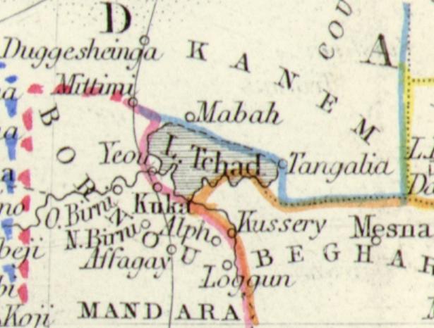
Ost-Africa und Madagascar " (East Africa
& Madagascar) after Major Radefeld, published in Illustrationen
zu Meyer's Neuem Konversations-Lexicon, 1860,
the map being dated 1857. The original is a very detailed steel engraved map with
original outline hand colouring, measuring 18.5 x 25 cms plus margins. Click
here for detail showing part
of the map at full resolution (500 dpi). Click the small image
to the left for a larger low resolution version. (Ref sm0021). Digital
image size 14.5 mb at 500 dpi. "
Ost-Africa und Madagascar " (East Africa
& Madagascar) after Major Radefeld, published in Illustrationen
zu Meyer's Neuem Konversations-Lexicon, 1860,
the map being dated 1857. The original is a very detailed steel engraved map with
original outline hand colouring, measuring 18.5 x 25 cms plus margins. Click
here for detail showing part
of the map at full resolution (500 dpi). Click the small image
to the left for a larger low resolution version. (Ref sm0021). Digital
image size 14.5 mb at 500 dpi.
Price 5
USD, Click here to buy
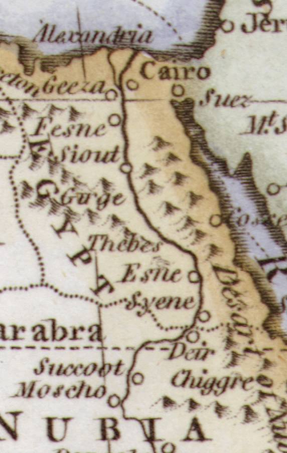
_tn.jpg) "... Hanc Aegypti (Magnae Bonarum Artium Magnae Virorum Parentis) Tabularum " (Egypt) drawn and engraved by Thomas Jefferys, published in Description of the East, 1743. The original is a detailed copper engraved map. Click
here for detail showing the Cairo area at full resolution (400 dpi). Click the small image
to the left for a larger low resolution version. (Ref sm0044). Digital
image size 21 mb at 400 dpi. "... Hanc Aegypti (Magnae Bonarum Artium Magnae Virorum Parentis) Tabularum " (Egypt) drawn and engraved by Thomas Jefferys, published in Description of the East, 1743. The original is a detailed copper engraved map. Click
here for detail showing the Cairo area at full resolution (400 dpi). Click the small image
to the left for a larger low resolution version. (Ref sm0044). Digital
image size 21 mb at 400 dpi.
Price 5
USD, Click here to buy
_tn.jpg) "Egypt and Arabia Petraea" drawn and engraved by J.Rapkin, published in Tallis's illustrated Atlas ..., 1851. The original is a detailed steel engraved map with original hand colouring. Click
here for detail showing the Cairo area at full resolution (600 dpi). Click the small image
to the left for a larger low resolution version. (Ref sm0051). Digital
image size 33.5 mb at 600 dpi. "Egypt and Arabia Petraea" drawn and engraved by J.Rapkin, published in Tallis's illustrated Atlas ..., 1851. The original is a detailed steel engraved map with original hand colouring. Click
here for detail showing the Cairo area at full resolution (600 dpi). Click the small image
to the left for a larger low resolution version. (Ref sm0051). Digital
image size 33.5 mb at 600 dpi.
Price 5
USD, Click here to buy
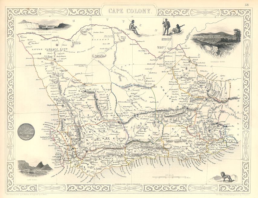
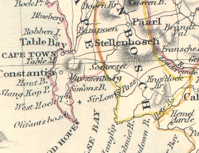
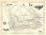 "Cape Colony" (South Africa, Tallis map) drawn and engraved by J.Rapkin, published by The London Printing and Publishing Company, about 1853. The original is a steel engraved map with original
hand colouring. Click
here for detail showing part
of the map at full resolution (400 dpi). Click the small image to the left for a larger low resolution version. (Ref sm0158). Digital image
17.6mb at 400dpi. "Cape Colony" (South Africa, Tallis map) drawn and engraved by J.Rapkin, published by The London Printing and Publishing Company, about 1853. The original is a steel engraved map with original
hand colouring. Click
here for detail showing part
of the map at full resolution (400 dpi). Click the small image to the left for a larger low resolution version. (Ref sm0158). Digital image
17.6mb at 400dpi.
Price 5 USD, Click here to buy
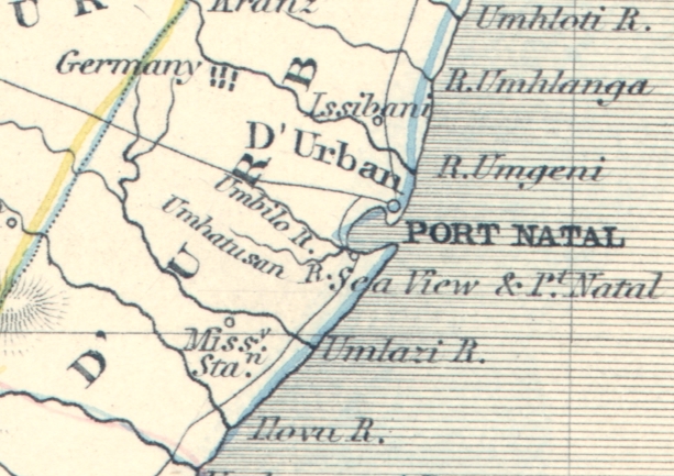
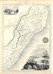 "Natal and Kaffraria" (Tallis map) drawn and engraved by J.Rapkin, published by The London Printing and Publishing Company, about 1853. The original is a steel engraved map with original
hand colouring. Click
here for detail showing part
of the map at full resolution (400 dpi). Click the small image to the left for a larger low resolution version. (Ref sm0160). Digital image
16.6mb at 400dpi. "Natal and Kaffraria" (Tallis map) drawn and engraved by J.Rapkin, published by The London Printing and Publishing Company, about 1853. The original is a steel engraved map with original
hand colouring. Click
here for detail showing part
of the map at full resolution (400 dpi). Click the small image to the left for a larger low resolution version. (Ref sm0160). Digital image
16.6mb at 400dpi.
Price 5 USD, Click here to buy
|
|

-l.jpg)
-l.jpg)
.jpg)
-l.jpg)

.jpg)
.jpg)
.jpg)

-d.jpg)
-d.jpg)
-600-d.jpg)
-d.jpg)
-d.jpg)
-d.jpg)
-d.jpg)